
Olle Wängborg
12. Lysekil-Skal
- Length
- 12.5 km
- Degree of difficulty
- Blue
- Estimated time
- 4h
This section of the Kuststigen-trail offers the hiker the beautiful and exciting nature reserve Stångehuvud, with a fabulous view of the sea.
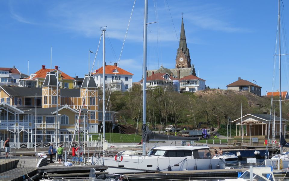
The stage starts in the center of Lysekil, with Lysekil's church in the eye. You can get here easily by car, bus or by ferry from Fiskebäckskil. The trail passes Havets Hus and soon reaches the Stångehuvud nature reserve. The view of the sea is fantastic and the trail goes over an exciting stone landscape. Observe that the trail through the reserve is primarily marked by being painted in white and red on stones and rocks.
Alongside Kuststigen, it is also possible to follow Lysekil's City Walks through the central parts. Where, for example, you can choose to go the child-friendly blue walk, which is combined with tip questions, or follow the historical walk, where you can see how places and buildings looked 100 years ago.
The new Västerhavspromenaden winds its way out towards the North Sea. Here you walk along the beautiful granite cliffs, with a wonderful view out to sea! The bridge promenade itself blends nicely into nature where it is completely designed according to the rock formations it is built around. The walk takes you between Alevik and Valbodalen. On the way you pass Lilla Långevik and Stora Långevik. The entire walk is accessible, so it's fine to get around with a pram as well as with a walker and permobile. There are plenty of benches and resting places along the entire walk. Bring swimwear and be sure to take a dip at one of the ladders along the promenade. For the brave, there is also a diving tower from which to swim. If you feel that your stomach sucks during the walk, there are two barbecue areas that are fine to use.
The trail passes a couple of wind turbines. Here, too, the view of the sea is fantastic. If you make a small detour to the right just after the wind turbines, you can take the opportunity to visit a genuine small vineyard! Via Dalskogen and past the sports hall, the trail continues north and meets the sea again near the campsite in Trälebergs kile.
Where the trail meets the major road between Lysekil, Brastad and Brodalen, it finally turns onto a pedestrian and cycle path along the road and soon arrives at the stage finish.
There is a bus here that takes the hiker back to Lysekil or towards Brastad and Brodalen.
Distance: 12,5 km
Time: 4 h
How to get here: In Lysekil harbor find the bus stop Lysekil Södra Hamnen. In Skal is the bus stop Skal.
Surface: Asphalt, dirt road, rocks
Don't miss: Bar Head Nature Reserve
12.5 km
Degree of difficulty
About Difficulty Grading
The grading is tailored for Swedish lowland trails that adhere to the quality criteria established by the national framework for hiking trails.
Even and firm ground: The terrain is generally flat. The hike requires no need to use your hands for support. No obstacles. Bridges are always present when crossing waterways.
Uneven and/or soft ground: Some changes in elevation. Certain sections may require hand support to maintain balance. There may be obstacles such as low stiles and short stairs. Minor obstacles like stones and roots. Boardwalks are present.
Loose or slippery ground combined with steep sections: Technical parts require hand support. There may be obstacles such as high stiles and longer stairs. Frequent sections with stones and/or roots. Boardwalks with deeper surrounding water.
Note: One or more of these features may be present along the trail section.
Blue
4h
- Hav
- Klippor
- Naturreservat
- Utsikt
- Tätortsnära
- Badplats
- Vandringsled
- Kuststigen
- Tätortsnära
- Naturreservat
- Hav
- Badplats
- Utsikt
- Klippor
- Vandringsled
- Kuststigen
- Tätortsnära
- Naturreservat
- Hav
- Badplats
- Utsikt
- Klippor
- Vandringsled
- Kuststigen
- Tätortsnära
- Naturreservat
- Hav
- Badplats
- Utsikt
- Klippor
- Vandringsled
- Kuststigen
- Tätortsnära
- Naturreservat
- Hav
- Badplats
- Utsikt
- Klippor
- Vandringsled
- Kuststigen
- Tätortsnära
- Naturreservat
- Hav
- Badplats
- Utsikt
- Klippor
- Vandringsled
- Kuststigen
- Tätortsnära
- Naturreservat
- Hav
- Badplats
- Utsikt
- Klippor
- Vandringsled
- Kuststigen
- Tätortsnära
- Naturreservat
- Hav
- Badplats
- Utsikt
- Klippor
- Vandringsled
- Kuststigen
- Tätortsnära
- Naturreservat
- Hav
- Badplats
- Utsikt
- Klippor
- Vandringsled
- Kuststigen
- Tätortsnära
- Naturreservat
- Hav
- Badplats
- Utsikt
- Klippor
- Vandringsled
- Kuststigen
- Tätortsnära
- Naturreservat
- Hav
- Badplats
- Utsikt
- Klippor
- Vandringsled
- Kuststigen
- Tätortsnära
- Naturreservat
- Hav
- Badplats
- Utsikt
- Klippor
- Vandringsled
- Kuststigen
- Tätortsnära
- Naturreservat
- Hav
- Badplats
- Utsikt
- Klippor
- Vandringsled
- Kuststigen
- Tätortsnära
- Naturreservat
- Hav
- Badplats
- Utsikt
- Klippor
- Vandringsled
- Kuststigen
- Tätortsnära
- Naturreservat
- Hav
- Badplats
- Utsikt
- Klippor
- Vandringsled
- Kuststigen
- Tätortsnära
- Naturreservat
- Hav
- Badplats
- Utsikt
- Klippor
- Vandringsled
- Kuststigen
- Tätortsnära
- Naturreservat
- Hav
- Badplats
- Utsikt
- Klippor
- Vandringsled
- Kuststigen


Highlights along the section
Here are some places that are frequently visited and appreciated by others.